What is the Grand Staircase-Escalante National Monument (GSENM) anyway? I’m willing to bet that most people have never heard of it, and we’re here to tell you that you MUST add it to your travel bucket list! The National Monument spans approximately one million acres of America’s public lands in Utah, and is the largest administered by the Bureau of Land Management (BLM). Because of its remote location and rugged terrain this area was one of the last places in the continental United States to be mapped. Its unique geology and rich history make it truly special. GSENM is filled with loads of neat monoliths, slot canyons, natural bridges, and arches. The Ancestral Puebloans and Fremont Cultures both lived here around AD 950-1100, leaving behind evidence in the form of rock art panels, occupation sites, campsites and granaries. Modern tribes, including the Southern Paiute and Navajo, also lived in this area, and trails, inscriptions, ghost towns and cowboy camps left by early Mormon pioneers can be found within the monument too. GSENM has an area with the best and most continuous records of Late Cretaceous life in the world—a geologic period that lasted from about 145 to 66 million years ago. New dinosaur species have even been discovered there! Keep reading and we’ll convince you why to visit this awesome and often overlooked National Monument in Utah.
General Information about the Grand Staircase-Escalante National Monument
How to Get There
The GSENM is located in one of the coolest parts of Utah, extending east from Bryce Canyon to Capitol Reef National Park and the Glen Canyon National Recreation Area and south to the Arizona state line, and borders the Dixie National Forest in the north. Most travelers drive right through the GSENM on Byway 12 to get from Bryce Canyon to Capitol Reef, so it’s easy to add as a stop while visiting these two National Parks and the other “Might Five” (Arches, Canyonlands and Zion). Within the monument are three distinct units: the Grand Staircase, Kaiparowits Plateau, and Escalante Canyons. While there are several main paved roads through this vast and remote monument—US-89 and Byway 12—many of the trailheads are on unpaved roads that range in condition from graded to sandy to completely unmaintained. A few other notable routes through GSENM include Skutumpah Road, Cottonwood Canyon Road and Hole-in-the-Rock Road, all of which are unpaved. There is no official entrance into the National Monument and therefore no entry fee, but you will incur costs for special permits or day-use passes. Overnight permits are required for camping and backpacking within the monument. A great place to get information about GSENM is at the Monument Headquarters located in Kanab, 745 East Highway 89, UT 84741. There are also several smaller visitor centers at the Paria Contact Station, Big Water and Cannonville. The helpful staff can provide details on weather and road conditions within the monument, things to do, and this is also where you can pick up maps and permits.
When to Visit
Although the monument is open 24/7, the wide range of weather conditions certainly make some seasons better to visit than others. The weather can vary greatly with the season and changes in elevation, with temperatures swinging as much as 30 degrees in the same day. The GSENM sees its highest traffic during spring and fall months, i.e. the shoulder seasons. March through May can bring pleasant sunny days with high temperatures between the 50s-60s, but the weather can also be unpredictable; rain, hail, snow and high winds are not uncommon in the spring. September, October and November have the most stable weather of all seasons, with high temperatures typically in the 70s-80s and lows in the 40s-50s. The days are often clear and mild, and the evenings are cool. The autumn leaves begin to change color in September, adding another layer of beauty to the landscape. Summer days can be brutally hot with desert temperatures reaching the 90s-100s. Thunderstorms are also more common, increasing the chance of flash floods, which can be especially dangerous if you’re exploring the areas popular slot canyons. Winter is cold and windy, with snow rendering some areas of the monument inaccessible. Many of the unpaved and unmaintained roads throughout GSENM become impassible, even to 4WD vehicles, after snow and rain. Be sure to research the road conditions before heading out on adventures in the monument. We had to remove a few places from our list because we had a 2WD car and 4WD was recommended for some of the roads. The last thing you want is to be stranded in the remote high desert of Utah!
Where to Stay
Because the area is so massive there are a variety of lodging options near and within the boundaries of Grand Staircase-Escalante. The town of Kanab is located right outside the southwest corner of the monument, and has the largest selection of hotels, lodges and vacation rentals within GSENM. But accommodations can also be found in smaller towns, such as Escalante, Boulder, Cannonville, Bryce Canyon City and Big Water. There are numerous RV parks, and established campgrounds including the Whitehouse Campground, Kodachrome Basin State Park, Escalante Petrified Forest State Park and Calf Creek Falls Recreation Area to name a few. Plenty of dispersed camping is available on public lands throughout the monument, some popular locations include Hole-in-the-Rock Road and Harris Wash. A free overnight permit is recommended for dispersed camping outside of developed campgrounds, which can be picked up at one of the visitor centers listed above.
History of the Grand Staircase-Escalante National Monument
National Park vs. National Monument
For starters, it helps to understand the difference between a National Park and a National Monument. (I know I always wondered, so I finally Googled it to write this blog!) According to the National Park Service website, the biggest difference is the reason for which each is established. National Parks are areas set aside by Congress for the use of people, because of some scenic feature or natural phenomena. National Monuments are areas reserved by the government because they contain objects that are historic, prehistoric, or of scientific interest. Monuments are typically established by Presidential Proclamation, but sometimes by the direct action of Congress. The National Park Service administers most monuments, though some are managed by the Forest Service (those in National Forests), or the War Department if it has military significance. Besides Grand Staircase-Escalante, there are many other National Monuments located in Utah: Golden Spike National Historical Site, Timpanogos Cave National Monument, Dinosaur National Monument, Hovenweep National Monument, Natural Bridges National Monument, Rainbow Bridge National Monument, Bears Ears National Monument and Cedar Breaks National Monument.
The 1906 Antiquities Act is law that empowers the President to designate monuments on public lands. The Presidential Proclamation 6920, declared in September of 1996 by President Bill Clinton, established this large chunk of the Utah backcountry as the Grand Staircase-Escalante National Monument. This protected nearly 1.7 million acres of land filled with scientific and historic discoveries. As stated in the proclamation itself, “the area presents exemplary opportunities for geologists, paleontologists, archeologists, historians and biologists,” and called it a “geologic treasure.” And after having been there, we can attest to that! The proclamation goes on to describe its various treasures and criteria for declaring it a National Monument.
Monument Modifications and Controversy
Until it became the center of a controversial political issue in 2017, GSENM wasn’t even on our radar. President Donald Trump scaled back the monument size, reducing it by 861,974 acres to 1,003,863 acres—cutting it almost in half. According to the amendment to Proclamation 6920, 20 years of research has helped to determine the monument’s critical areas while also identifying that many objects noted originally are not actually unique to GSENM, and have no scientific or historic interest. To be clear, this includes geologic features like arches, natural bridges and serpentine canyons and portions of the Water Pocket Fold; signs of the past left behind by earlier inhabitants, like the ancient rock art panels, granaries, camp and occupation sites of the Ancestral Puebloans and Fremont Culture; and objects and historical sites of the early Mormon settlers who called this land home. Basically they’re saying these things exist in other regions so they aren’t that important at GSENM, and that the smaller area will be easier for the BLM to manage. Also, those 861,974 acres that used to be our public lands are now open for entry and sale, for mineral and geothermal leasing, and mining. We can agree to disagree all day, but I feel that these objects and areas now excluded from the monument are pretty awesome and extremely significant. And I’m not the only one, as the Biden administration has already initiated steps toward restoring the boundaries of both the GSENM and Bears Ears National Monument, another in Utah that was drastically reduced.
Why GSENM Was Established (i.e., Why it’s Awesome)
The unique treasures of the Grand Staircase-Escalante National Monument have largely been preserved due to its remoteness, limited travel corridors and low visitation. In order to maintain the integrity of this place it must continue to be protected. There are areas of vegetation in GSENM that have existed since the Pleistocene era, i.e., 2.6 millions years ago to about 11,700 years ago, a time period most famous for the last Ice Age. Natural processes here have been totally unaltered by man, so let’s keep it that way! Because this vast monument varies so much in elevation, topography and climate, it hosts a diverse amount of wildlife, including mountain lions, bears, desert bighorn sheep, and over 200 species of birds like the majestic bald eagle and peregrine falcon. Since 2000 nearly 4,000 new fossil sites have been documented within the GSENM. The area is world-renowned for rich fossil resources, including 16 species that have been found nowhere else. North America’s oldest mosasaur (marine lizard a.k.a sea monster) was discovered here, along with new dinosaur species like the Diablocerotops eatoni (a relative of Triceratops) and Lythronax argestes—the ‘Gore King of the Southwest’ and great uncle to T-Rex! (I love dinosaurs, this is so exciting!!!) In 2009 a BLM employee also discovered the first Kosmoceratops, a rare horned dinosaur. A nearly complete skeleton of a bipedal (i.e. animal that walks on two feet) crocodilian fossil named Poposaurus was found in the Circle Cliff area. (Imagine a giant crocodile walking on two legs—NO THANKS!) Also discovered in GSENM were fossils of ancient water mollusks, turtles, crocodilians, lizards, dinosaurs, fish and mammals, and exceptional pieces of ancient petrified wood.
Grand Staircase-Escalante is also rich in human history. Prehistoric peoples like the Ancestral Puebloans and Fremont Cultures both inhabited the same territory around 950 to 1100 AD. It’s estimated that the Fremont, a partly nomadic, hunting and gathering culture that also farmed, lived in this area of central Utah from about 1 to 1300 AD. The Ancestral Puebloans were an ancient Native American culture who scientists believe emerged around the 12th century BC. The group that lived in the present day Four Corners region of the United States are referred to as the Anasazi, which in Navajo translates to “ancient enemies.” Because of this negative connotation, the Ancestral Puebloans do not appreciate that name though. These ancient people largely relied on farming to sustain themselves and are thought to have resided in the area from 200 to 1300 AD. Interestingly both cultures pretty much disappeared by 1300 AD and much of the research indicates that drought conditions were likely to blame. Around the same time, modern hunter-gatherer tribes like the Southern Paiute and Navajo arrived in the region. Mormon pioneers also settled in this area, one of their landmarks still standing is Dance Hall Rock. They camped here, and held meetings and dances while they built Hole-in-the-Rock Road. At the turn of the 20th Century, the old Paria townsite, now a ghost town, was the only town and post office in the area. The Boulder Mail Trail was a route used to transport mail between the towns of Escalante and Boulder in the early 1900s. This trail is still visible today and popular for adventurous backpackers.
Things to do at Grand Staircase-Escalante National Monument
If we haven’t yet convinced you why this National Monument is so cool, let’s continue. The GSENM has been divided into three distinct units: the Grand Staircase, Kaiparowits Plateau, and Escalante Canyons. It’s a recreation paradise for activities like off-roading, canyoneering, hiking, camping, fishing, horseback riding, star gazing, and a photographers dream with all its unique rock formations and landscapes resembling what you’d imagine Mars to look like. The Grand Staircase is a geologic staircase of sedimentary rock, like a giant rock cake where each layer (youngest on top, oldest at the bottom) represents a span of the earth’s time. This colorful sequence of cliffs and plateaus reaches from Bryce Canyon and GSENM through Zion National Park and to the Grand Canyon. This unit also encompasses large sections of the White Cliffs and Vermilion Cliffs.
The Grand Staircase and Kaiparowits Plateau appear to be divided largely by the Paria River. This super rugged canyon country is home to Utah’s most extensive network of slot canyons like the upper Paria Canyon system, Wire Pass, and Buckskin Gulch—which is said to be the longest and deepest slot canyon in the world. Technically some of these attractions now fall outside the new GSENM boundary line, but were included in the original proclamation. They’re still awesome so we’re highlighting anyway. (You can review this detailed GSENM boundary map provided by the BLM to compare the original plot of land protected by Proclamation 6920 versus the new monument area. Though not as detailed, I found this simple map a bit easier to read and understand the differences.) The Wave is also nearby; it’s a famous rock formation in Coyote Buttes North located between Paria Canyon and the Vermillion Cliffs National Monument on the Utah-Arizona border. Don’t get too excited, because there’s no riding The Wave without planning and a stroke of good luck. In order to protect this fragile environment, the BLM limits visitation through an insanely competitive lottery system to obtain permits—and they only provide 20 per day. And there are MANY people vying for those coveted permits, so if it’s on your bucket list we suggest applying with a group to increase your chances.
Cottonwood Canyon Road is a 47-mile scenic route that crosses through Utah’s rugged desert wonderland. It stretches from US-89 near Kanab to Kodachrome Basin State Park at its north end. The road is unpaved and typically okay for 2WD vehicles, but definitely better suited to 4WD. However, road conditions can become muddy and impassable even for 4WD vehicles in the spring or after storms, so be sure to check conditions at one of the monument’s visitor centers. Not only is the drive itself out-of-this-world, but you can also access some pretty epic stuff from Cottonwood Canyon Road, like the Cottonwood Narrows Trail, the 150-feet high sandstone Grosvenor Arch, and Kodachrome Basin State Park. The park was named after the popular Kodachrome color film, which was inspired by its colorful layers of sandstone. The main attractions at this state park are the 67 stone spires located throughout. Kodachrome Basin also has a developed campground and popular recreation activities include hiking, mountain biking and horseback riding.
The Kaiparowits Plateau is the highest, wildest and most remote unit at GSENM, and also the least visited. Be sure to fill your vehicle with gas, and if you’re planning to explore deep in this area you may want to consider bringing extra gas, tires, water and emergency supplies, because this unit is a RUGGED land of plateaus and deep canyons. (You’ll want to be prepared somewhere that has wilderness study areas with names like Death Ridge and Carcass Canyon!) Thousands of fossils have been uncovered in the Kaiparowits Plateau, deeming it one of the richest fossil sites for the Late Cretaceous period, i.e., 65 to 145 million years ago. Duck-billed dinosaurs are commonly found in this area, and two species of tyrannosaurs were discovered here! And get this (this blew my mind)—some species here have been so well preserved that their remains were discovered with skin. The Kaiparowits Plateau contains the East Kaibob monocline’s Cockscomb Ridge, named for its bright color and similarity to a rooster’s comb. The Burning Hills is an area that has been scorched bright red by the smoke of underground coal seems. Some researchers speculate that the coal has been burning for an indefinite and very long time. (WHAAAATT like hills on fire?!) In fact, billions of tons of coal lie underground in the Kaiparowits Plateau region. Development of this area by the coal industry was ultimately halted by the establishment of the monument in 1996, which has helped to preserve its rugged and wild nature.
Narrow canyons and towering walls are all the rage in the Escalante Canyon, the best known and most visited of the monument’s three units. The Upper Escalante Canyons feature numerous arches and natural bridges, and magnificent striped and colorful canyon walls. Places of interest within this area include Death Hollow, Calf Creek, Coyote Gulch, Hurricane Wash, Escalante Petrified Forest State Park and Hole-in-the-Rock Road. A number of notable destinations are accessed from the unpaved Hole-in-the-Rock Road, a historic Mormon Wagon route connecting Escalante to Lake Powell. This includes Fiftymile Creek, Peekaboo Canyon, Spooky Gulch, Zebra Slot Canyon, and the Devil’s Garden, a desert playground with sandstone hoodoos, narrow passages, and arches. From Escalante, Hole-in-the-Rock Road is a righthand turn off Byway 12 about about five miles north of town. Hell’s Backbone, billed as one of Utah’s most scenic roads, is a narrow and winding unpaved 38-mile route that connects the Escalante and Boulder, and is an alternate to the paved Byway 12. Hell’s Backbone Road closes in the winter when it becomes impassable due to snow. Besides hosting gorgeous views it also provides access to the popular Death Hollow hiking trail. In the town of Boulder, the Anasazi State Park Museum was established to preserve the site of one of the most populated Ancestral Puebloan communities west of the Colorado River, a village occupied between AD 1050 to 1200. Today visitors can view ancient artifacts and a life-sized replica of a dwelling at the museum.
Our Adventures at Grand Staircase-Escalante
Wire Pass Slot Canyon
Our first taste of Grand Staircase-Escalante was hiking the Wire Pass trail, an amazing slot canyon in the Paria Canyon/Vermilion Cliffs Wilderness area that meets up with the much longer Buckskin Gulch. Technically Wire Pass does not lie within the current boundaries of the monument (it was in the original proclamation), but it’s pretty dang close and if you’re heading to this area of Utah it’s worth checking out. And who knows, by the time you read this the boundaries could be readjusted again. I’ve included some photos below of Wire Pass and you can also check out more details about the hike in our blog post, One Day and Two Nights Exploring Kanab, Utah. Wire Pass started our obsession with slot canyons! It’s a relatively easy and short hike that we recommend for anyone traveling near Kanab.
Escalante, Utah
As stated previously, the GSENM spans a huge area. Bryce Canyon National Park was actually on our way from Kanab to Escalante, so we stopped there for a quick hike in the hoodoos. After leaving Bryce we originally planned to camp on public lands at Hole-in-the-Rock Road, but because we were running late, decided to find a cheap hotel instead of setting up camp in the dark. Note, if you do plan on dispersed camping in the monument be sure to stop by a visitor center to grab a free overnight permit first. Lucky for us, the Prospector Inn was advertising $79 rooms on their bright neon sign. It was nothing special, but for $79 we got exactly what you’d expect and exactly what we needed—a no frills, straight out of the 1990s room with a fridge, microwave and hot shower. A guy staying at the hotel had just arrived back with pizzas from Escalante Outfitters, which he highly recommended along with their coffee and breakfast. (Of course it didn’t come as a surprise when we learned the dude was also from Portland; we Portlanders always know where to find the good food!) This was the second outdoor store we encountered on our trip that also doubled as a cafe; I suppose gear and coffee go hand in hand when it Utah! We were thrilled to find that Escalante Outfitters served cold brew coffee, legit lattes, and tasty breakfast items like the quiches and calzones (I ate the bacon + cheddar quiche and the ham + cheese breakfast calzone, and I’d order them again). The outdoor store had quality gear and some decent sale items, along with a campground. We tried to score one of their cute log cabins but they were already booked by the time we arrived to Escalante after dark. Earlier we had passed a convenience store advertising their “Beer Cave,” so we went back there to load up on refreshments, microwaved some raviolis and called it a night to rest up for the Lower Calf Creek Falls hike.
Lower Calf Creek Falls
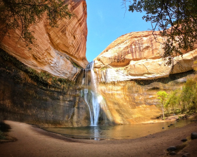
The next stop on our agenda was the hike to Lower Calf Creek Falls. Even though we have our fair share of waterfalls in Oregon they just never get old, and desert waterfalls are especially intriguing. Fun fact, Calf Creek Canyon was named for its use as a natural cattle pen at the end of the 19th century. The drive through the monument to the trailhead is so cool, as you pass by some pretty unique landscapes and rock formations. Along the way, the Kiva Koffeehouse suddenly emerges out of nowhere—it’s the last thing we expected to see where we did, but yes, there’s literally a coffee shack in the middle of the monument on Byway 12. The trailhead for Lower Calf Creek Falls is located at the Calf Creek Recreation Area, which is only about a 20-30 minute drive from Escalante. This is the only maintained hiking trail in the monument (I told you this place is rugged)! We arrived to the recreation area parking lot between 10-10:30 and it was already packed. We were fortunate to grab one of the last spots but the cars kept streaming in, so we definitely recommend getting there early in the morning. When we left at 2:30 there were no spots available in the lot and cars were parking along the shoulder of Byway 12, which I’m pretty sure you’re not supposed to do. Also at the Calf Creek Falls Recreation Area is a small hike-in campground (already fully booked) and restrooms. A $5 day use fee to use the trail is payable at a small pay station.
Calf Creek Falls is probably the most well known feature of Grand Staircase-Escalante National Monument. The waterfall actually has two tiers, Upper and Lower Calf Creek Falls. The lower tier is the taller of the two at 126 feet. Upper Calf Creek Falls is a two-mile roundtrip hike that is accessed from another trailhead, but we didn’t have time to check it out on this trip. Instead we opted for the more popular six-mile roundtrip hike to Lower Calf Creek Falls. Overall it’s a pretty easy trek with little elevation change. However, the trail is mostly sand so it’s basically like walking on a beach for six miles. The trail follows the meandering creek, with water so clear that we saw tons of little trout swimming along the way. The vertical striped canyon walls are like nothing we’ve ever seen. I’m reading the interpretive guide (picked it up at the trailhead) as I write this and learned that this colorful striping is actually caused by microbes; it’s called desert varnish, and scientists think it may also exist on Mars! Everyone always says Utah looks like Mars, and there’s potentially a real connection to the red planet! Side note, learn a lesson from me here—do your research. Read the interpretive guide or hike information while you’re at the place and not months later when you’re home like me. I can’t tell you how many times we’ve missed important facts or found out there was something cool that we missed. Like, the ancient granaries and pictographs left behind by the Fremont Culture that we missed along the trail to Calf Creek Falls. For more information about preparing for responsible outdoor recreation, check out our post: Practices for Enjoying the Outdoors Responsibly. (Confession: we try our best to adhere to these principles, but I fully admit we’re guilty of slipping. No one one is perfect, and you also don’t know what you don’t know!)
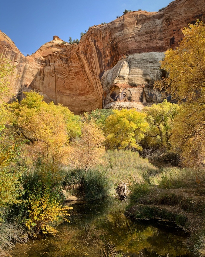
It was a real added bonus to complete this hike during the fall, as the changing colors of the leaves really complimented the canyon walls and wetlands. Much of this hike is exposed and at times that sun gets pretty warm. As you get nearer to the falls the trail is more shaded by the trees, bringing some sweet relief after all the sunshine. You’ll hear the waterfall in the distance before you see it, and then you’ll feel the temperature begin to drop, and all of a sudden there is Lower Calf Creek Falls poking through the trees. And it is STUNNING. We’ve seen hundreds of waterfalls and this one stopped us in our tracks. It’s a real banger, just spilling over that huge cliff into a big pool of refreshing water. I’ve seen people swimming here in photos, but the temperature is so much colder at the base of the falls that no one was swimming on this October afternoon. Seriously, it’s shocking how much the temperature drops at the waterfall! Hikers were spread out all around the pool, relaxing, taking in the sights, and enjoying snacks. There were probably only about 20 people there, but the area is so large that it never felt crowded. On average this hike takes most people between three to four hours to complete. It ranks up there as one of the most beautiful hikes we’ve ever done, so be sure not to miss it if you’re visiting this area of Southern Utah. Waterfall chasers, add this one to your bucket list!
Escalante Petrified Forest State Park
You know what they say about those early birds, (which normally, we’re not) and we got our worms on this day! After finishing the hike we headed back to Escalante for the evening, this time hoping to score a campsite at the Escalante Petrified Forest State Park. Most of the sites were booked in advance but I could see at least one walk-in site available on Recreation.gov. At 3:00 p.m. we cruised through the campground loop and found the last open walk-in site, wahoo! PRO TIP: Check the dates written on the site reservation tags. Many people assume that if there’s a tag, the site is reserved. But sometimes it’s an old tag, or the reservation starts the next day. We’ve scored sites like this before, and that’s how we got this one—we literally followed a car looking for a campsite and they passed right by this one, probably because there was a tag. The fee for camping is $25 per night, payable by cash or check at the pay station in the park, or online. The campground has tent and RV sites with electric hookups and nearby potable water, restrooms and hot showers, and firewood for sale. The state park is also right next to a small reservoir, and best of all, there’s an ancient petrified forest on the premises.
We didn’t know what to expect from petrified wood, and honestly, it sounds kind of boring. I couldn’t have been more wrong, petrified wood is sweet! It’s literally wood turned into stone; logs of rainbow-colored rocks and crystals cover the landscape here where an ancient forest once stood, probably the same time that dinosaurs walked the earth. There is a small paved loop trail near the visitor center with some pretty impressive specimens, but the most colorful petrified wood can be found on the loop trail up on the hill. This wood is for looks only, so please leave it where you found it. (It’s rumored that those who take the petrified wood are haunted and brought bad luck.) We’re so glad we had enough time to check out this geologic wonder. Escalante Petrified Forest State Park is a nice little developed campground that we’d certainly visit again. Our only complaint for the one-night stay is that we had the rudest, most inconsiderate neighbors in a RV who started running their generator at 4:00 a.m. because “they were cold.” Like hi, we’re in a freaking tent over here (and we were fine)! Most campgrounds, including this one, have rules and certain hours you’re allowed to use generators, so don’t be a jerk and be considerate of everyone around you. Needless to say we didn’t get much sleep after that, but it didn’t stop us from enjoying our next adventure at Capitol Reef National Park.
In closing, all we have to say is that you need to add the Grand Staircase-Escalante National Monument to your Utah bucket list. And we only saw a tiny bit of it; there is so much more we plan to go back and explore! Just because you’ve never heard of a place doesn’t mean it’s not amazing, and just because this isn’t a National Park or one of Utah’s “Mighty 5” doesn’t make it any less awesome. It must get overlooked because Utah is filled with so many otherworldly sights. But now that you’ve read this, do yourself a favor and go explore this underrated gem, you won’t be sorry.
Thanks for reading! Let us know if you have any questions, or if you know of other awesome stuff to see at the Grand Staircase-Escalante National Monument.